You may recall, if you are a regular reader of these posts, that the Quest to ride in all the states had its origins in an "Iron Butt" fete... two riders rode in all the lower 48 states in less than a week. The Iron Butt Association is a real and serious organization that sanctions long distsnce motorcycling events. Without going into too much detail the entry level Iron butt event requires aspiring members to ride and document with signatures and receipts a thousand miles in 24 hours. There is a coast to coast challenge that requires riders to cross the continent on 50 hours or less... that's called the 50 CC. Every two years the IBA sanctions a rally/scavenger hunt that takes two weeks and winners often log 12000 miles and traverse North America from Alaska to Key West as well as the other cornerd and points in between.
Tomto and I have long contemplated the 1000 miles in 24 hours thing but the past few days have put that idea to rest. Old guys need more realistic goals, thus the Iron Cheek. Entry level challenge: 500 miles during daylight hours with two required stops for food-- must sit down and eat and at least one item must be ordered from the 'senior menu'. Riders must be at least 65 years of age. The entry level ride earns successful applicants the "Half Moon" award.... we are contemplating a license plate frame, woven patch, a pin, and a decal.
The next level chllenge... 2 back to back 500 mile days earns the successful rider the 'full moon' award.
We're working on other events such as a do it yourself rally, special awards and titles and trying sot work 'Moon" and "Butt" into everything. We welcome your suggestions and you help in build a FAQ for prospective members.
Sunday, August 24, 2008
Last Night Out
The Journey began on July 24 when Tomto and I left Central Ohio on the Quest for the 49th state. Today is August 24th and we are nearing the last leg of the journey. We are staying the night in a Quality Inn in Greenfield, IN just 160+ miles from where we started. My intent was to chronicle as many of the sights and vistas from the road as possible. A near impossible task as I've discovered. The thinking time on the motorcycle is great for processing ideas and composing thoughts but without a recording device much is locked the the folds of the old gray matter perhaps never to see the light of day. This post will be a sort of brain dump as I ramble on about what may or may not be written about in more reflective posts when I get home.
Some things seen and thought about on the road:
Sign on a wrecking yard wall in Twin Falls, ID: "All cars run on used parts". That's true of us humans, too. Physical parts, mental parts, and spiritual parts. How those parts have been used and cared for, what accidents they've endured, and what repairs have been made all contributed to how well the 'used vehicle' runs today. Not sure where this goes but I'm thinking about it.
Taming a great river. The Columbia Gorge is beautiful and so is the peaceful river that runs through it. However, part of me longs to know the wild river that Native Americans and Lewis and Clark saw and braved before the Bonneville and other dams tamed it. I84 allows fast and awsome views of the gorge at 65 miles per hour, but what were the views from the game trails and even the old route 30 from the seat of a Model T.
Who dared to cross the great salt flats first. Why would anyone even begin to brave such a forbidding salt desert? And why?
Have the maze of islands through which the Alaska Marine Highway wends its way been thoroughly explored... have humans put their prints everywhere in this vast network?
What is it about gambling that draws us to keep trying against all the odds to win the jackpot? Is that the same gene or trait that keeps us alive in hopeless situations.
How are oral traditions different in societies that have no written language (like the First Nation people of the north) our friend John claims that the traditions are passed on word for word not as ever changing 'stories'.
What next after the 49th state?
Wednesday, August 20, 2008
Bonneville update
Bonneville Salt Flats, Middle of Nowhere, UT
Wednesday.
After disappointing runs the first few days the racer guys ditched the fuel injection in favor of the old reliable carburetor. The first run today was way better (162 and change) jst about 3 mph off the class record. As I type this the boys are disassembling the carb and scouring the pits for new jets to richen the fuel/air mixture which should push the Nissan over the record. In case you've forgotten the fine points of landspeed racing if a car beats the old class record the record must be 'backed up' the next morning and the average speed of the two runs stands as the new record if indeed the average is higher than the previous record.
One of the finest time on rhe salt is coming out before dawn to back up a record. New light makes the distant mountains to the west light up first, then the salt begins to glow as tne sun rises. We hope to be out on Thursday AM to back up a new record and to experience the new day. Loretta and Marlene are leaving tomorrow and Tom is arriving tonight so Thursday is the best last chance for a back up.
Tomto and Chemo-sabi will probable be back on the trail again Thursday althiyugh we are not sure of the return route.
It's warm again on the salt but not the 100+ we've experienced in the past. Looks like hot but dry travel to the east and I think I'm ready to be back in Ohio after 5000 miles in the saddle plus a 1000 or so on the ferry. We've still got close to 2000 miles between here and Columbus.
Tuesday, August 19, 2008
Buckeyes on the Salt
Bonneville Salt Flats, Middle of Nowhere, UT. Parked next to the Buckeye Bullet the OSU land speed electric race car. The Buckeye team have set up a satellite wifi system and it's unprotected so I've logged in.
Other Buckeyes of note are the McMeekin Brothers race team of which we are hangers on. Don and Jane McMeekin are the only family members here but several others are in support. To risk boring most of you I'll describe the race car: Don McMeekin is the chief architect and builder so the car reflects his artistry both mechanically and esthetically. Car number 280 started life in the 80's a a Nissan 240SX, a four seater, semi sporty sedan with exceptional aerodynamic for a production auto. The engine of the year, this is the 3rd in a series of unusual power plants, is a 1947 Buick Roadmaster straight 8... that's 8 (count 'em) cylinders in a row. The more common modern 8 is a V8... two banks of 4 cylinders sort of side by side. The Nissan came with a 4cylinder engine so the Buick is nearly twice as long and fits snugly under the hood necessitating rather lumpy blisters on the hood to clear the taller and longer engine and fuel injection.
The car draws a crowd when the hood is off... this is a very unusual configuration and beautifully executed. The body is a bright orange with silver racing stripes down the center. The engine is painted to match with stainless steel hoses, carefully routed and tied doen wiring and with discrete vintage Buick 8 logos on the valve cover.
The record in the XOGALT class is about 167 MPH and so far the best Don has been able to do is a bit over 150. Today (Tuesday) Don is pulling the fuel injection and replacing it with a carburator which, in this case, may provide more even fuel distribution to that long span of cylinders. As I type Don and other crew members are cutting a hole in that perfectly sculpted fiberglass hood and gringing another hole in the intake manifold to accept the carb plate. All tgus is being don 'on the salt' no electricity except from a small generator, under a make shift tent, all on a bed of salt. Stuff like this is going on all throughout the pit area which extends for more than two miles along the longest of one of three race courses. This whole experience exemplifies America's greatest natural resource: creative inginuity and the persistence to make lemonade from lemons and race cars from ancient castoffs.
Shameless education plug: When will we get back to nurturing the kids who are tomorrows Bonnevile racers, creative scientists, far out mathematicians and brilliant inventors who are not predicted by high-stakes testing. Bonnevile in a sense is The Christmas Past... when will our leaders wake up and see that this culture is fading and without emphasis on out of the box, out of this country, out of this world thinking other countries are going to eat our innovative lunch.
Sunday, August 17, 2008
Columbia River Gorge
Still at Mountain Home, ID
NOTE: Don't be alarmed, your eyes didn't go negative on you. I changed the template for the blog last night when the previous post appeared to have no text in it. I tried to type my post in the little word processor on my XO and it entered some HTML commands that changed all the text in the blog to black (I think) which does not show up well on a black background. So until I figure it all out I stick with the current format.
----------------------------------
The first view of the Gorge was some distance after I left the Portland area, I'd elected to take the Rt. 30 by-pass which took me through the more industrial fringes of Portland, my mistaken thought was that I'd be right close to the river. I wasn't until I joined again with I84 that the cliffs of the gorge came into view. As posted earlier, it had been a long and arduous afternoon. The sun was setting behind me and the cliffs, that appeared to be rather close together on either side of the river, were lit perfectly to emulate a lithograph I recalled of Lewis and Clark surveying their course from a promontory somewhere. I choose to believe that they were overlooking the Columbia River Gorge nearing the westward end of their epic journey.
The light and the hills appeared sort of gold and I had another of my WOW moments (I didn't try to stop for a photo this time). I84 closely follows the Columbia so the river is most always in view. It's broad and not very fast moving. The opposite (northern) shores are visible across the river and the southern cliffs are fairly close to the highway to the right although these are probably newly blasted to make room for the four lane. Being IN the gorge this way is impressive however, the real eye opener occurs when the rider takes the 'old road' cutoffs that are offered.
The original national highway through the gorge is US Rt. 30, known in Ohio and elsewhere as the Lincoln Highway. It's remnants wind not only with the river but with the terrain. Sometimes at the river level, sometimes high above. At points it hugs a more natural southern wall and it's at these points that it reveals spectacular waterfalls. In one 7 mile section of the old road, lined with old fashioned decorative concrete bidge abutments and white painted wooden guard rails, are three spectacular water falls. Each is close enough to be viewed from the road. There are parking spot near each fall and in a couple of cases gift shops and restrooms built of local stone in the charming slate roofed WPA style seen in state and national parks across the nation.
I can't recall the names of two of the falls, although one was nicknamed 'Bridal Veil', one was 'Horse Tail' and one was the third highest fall in the US. This seven mile ride was particularly enjoyable as the light was fading and the day was cooling from the 90's suffered earlier on I5.
Who could resist a side trip over the 'Bridge of the Gods'? I couldn't even though there was a toll. The bridge takes it's name from a Native American legend that tells of a natural bridge that the Great Spirit created in this site and set a woman to guard. She somehow failed in duty and the bridge was destroyed in a battle between waring tribes. In shame she went into solitary retreat and became Mt. St. Helens (not her real name) 90 miles to the north.
The current bridge while not as old as the legendary Native bridge is pretty old. It was originally built before the Bonneville Dam was finished in 1938 and has to be raised about 90 feet to clear the rising water behind the dam. There is a dollar charge for cars, to my surprise I got 50 cents change when I offer my buck for the bike.
The other side is, of course Washington again. I made my way as dark was falling, to Stevenson, WA , a place I'd randomly picked on MapQuest to spend the night. As luck would have the town was celebrating its annual Free Fair and homecoming and this happened to be the one hundredth such event. Quite a picturesque little place, a former logging town now dependant on tourism. As the free fair and the main part of town was fading in the mirrors and as Rt. 14's 2 lanes were growing darker ahead the glorious red and white 'Econo Lodge' sign popped into view. I got one of the last 2 remaining rooms (the Jacuzzi Suite), a AAA discount, advice on how to find the local Subway, a shower, and blessed cool sleep.
More on the Gorge next time.
Saturday, August 16, 2008
Week from Hell
Mountain Home, Idaho
Bellingham, WA to the Columbia River Gorge
Had the week from hell yesterday afternoon. After landing in Bellingham at the end of our 3+ days on the Alaskan Marine Highway we made the 60 miles to Everett and Bernadette and Jay's home without incident. I even remembered the tricky turn onto Friday Street that I missed a couple of times the last time we were here in 2005. The house is situated on a hill that overlooks much of Everett and even give a great view of Mt. Baker when she's out. Bernadette always has home improvement projects in the works. Since the last time the small garden in the front of the house has been enlarged and a covered gazebo has been added as has access to the flat roof in the rear that is now a flower filled roof garden and eating space. After a warm welcome a great breakfast and an upload of blog posts I bid a reluctant farewell to Bernadette, Monica, Mary (another Monica sister visiting from CA) Mary's husband Steve and daughter Lori, and of course Tomto, I hit I5 about 1:15. Four hours and 70 miles later I was still not out of the terrible traffic woods... Seattle, Tacoma, Olympia, military bases and all points in between conspired to impede my way to the Columbia River Gorge. If 70 miles of stop and go traffic is typical of the area I can't imagine how Boeing and Microsoft find anyone willing to strike out for work.... maybe traffic is the secret weapon that keeps noses to the grindstone rather than attempt to get home.
To be fair I encountered 3 well spaced vehicle fires that must have had an impact on the snarl that kept me on the bike in the HOV lane for nearly 5 hours. The first fire was near downtown Seattle, it was a crane truck on a Northbound on ramp... by the time I saw it the fire was out but it was smoldering and surrounded by fire equipment and police cars. Traffic in both directions was stop and go for miles. A teaser of 50 MPH and then another slowdown and then stop. A message board announced an 'incident' at 320th Street. We were now only in the double digits. Days later the 'incident' was revealed to be an articulated municipal bus that was totally burned to a shell in the southbound HOV lane. Rubber necking added a couple of rear end bang-ups to multiply the confusion.
By this time we are in full tilt Friday-get out -of-town rush hour. Endless lines of cars streaming in from every on ramp and pressuring vehicles toward the center where I am staking out my right as a motorcyclist to ride in the HOV lane. However, being in the HOV lane makes exiting, if I'd been foolish enough to get off in unfamiliar territory, very difficult. I must have looked rather cooked (did I mention that the Northwest is suffering a heatwave and the temp was in the 90's and I was in full protective gear that felt so good in the 40's in Alaska). A driver in a red Toyota Tacoma pickup waved a bottle of water out the window at me and I managed to snag it with my throttle hand without coming to a complete stop. Thank the motorcycle gods for flip-up helmets. I upped the chin guard and twisted off the cap with my teeth... I gulped most of the water and splashed the rest on my tee shirt. Probably saved me from a unwise stop in the center berm to get my own water bottle from the back of the bike. Another act of kindness from a total stranger.
The last vehicle fire was near Chehalis way south of Olympia but of course traffic backed and then stopped after only a few miles of 50 MPH.. By the time I arrived on the scene the origin of the fire was nothing more than a car size grease spot on the side of the road. However, this fire sparked a grass and brush fire that spread several hundred yard in all directions from the original burn. Smudged firefighters and their trucks were still on the scene. It appeared that the fire had also spread to northbound lane because there were trucks over there also. Miles of backup in both directions.
Finally made it to the exit that would take me into the Columbia River Gorge. Believe it or not I'd spend that afternoon week from hell all over again to see the Gorge as I did later. I'll save that for another post.
Friday, August 15, 2008
Four Days in Haines part 1
Note: I'm running behind. I entered some blog material while we were on the Alaska Marine Highway Ferry but there is too much stuff in my head to get it all down. This part 1 of 4 days in Haines may be the only part for a while. At the present moment I'm in Everett, WA at Bernadette and Jay's house. Bernadette is Monica's sister and I've stopped to have breakfast and to catch up on internet stuff. I'll be off on my own later today to connect with Loretta and the Bonneville gang. Don't know when my next internet connection will be but I hope to fill you in on the other 3 Haines days and the 3+ days on the Ferry as well as what happens on the way to Wendover, NV/Bonneville Salt Flats.
Four Days in Haines
As mentioned earlier crossing the border from BC to Alaska was almost too easy. Tomto is concerned that terrorists, at least ones that look like old Anglo bikers riding BMWs could easily sneak into the US at the this crossing. I suspect he is contemplating a call to Homeland Security and suggesting a more rigorous vetting of those crossing into the US. Never mind that Haines is probably 300 miles by road from the nearest US town or that one must pass through parts of British Columbia and Yukon Territory to get to that town which is the very strategic nerve center of Skagway.
Thirty nine miles from the border crossing is the 'Welcome to Haines' sign (we've got pictures). The Haines Highway splits to the right and continues on past the rather modest cruise ship dock to its end at Portage Cove where there is a small state park where backpackers and cyclist (pedalists) camp for $5 per night. The high school is out this way according to a recent grad who served us at the Lighthouse but we couldn't identify it. This tail od the Haines Highway runs along the Lynn Canal which is not really a canal but the saltwater passage that connects the Haines pennisula to larger waters to the south. Also above the end of the Haines Highway and the cruise ship dock rises Fort William H. Seward, once an US Army outpost housing up to 400 troops and dependents at the turn of the 20th century the fort was abandoned by the army after WWII and was purchased by a group of local veterans in hope of making it a tourist attraction. That venture failed, at least as a total entity. Many of the buildings have been purchased by individuals and some are used for residences and others as businesses. The two and three story white wooden buildings are on the side of a slope high above the Lynn Canal and surround a nine acre parade ground. On the street that runs parallel to the canal and the highway are the officers quarters, the commanders home, the surgeons home. At either end of this street are 2 perpendicular streets facing the parade grounds on which the hospital, recreation building, bachelor officers quarters, headquarters building, and the fire department buildings stand. At the base of the slope forming the fourth side if the parade ground is the surviving enlisted mens' barracks (the other barracks building burned in 1980's). All in all a remarkable private effort in preservation, the building all show signs of hard winter and advanced age and a so large that heating them in this climate must be a challenge.
The Headquarters building and the BOQ have been joined to form the Halsingland Hotel, probably THE hotel in Haines even though it needs paint and the chimneys are few bricks shy of a full stack. The hotel lobby is frontier shabby but the restaurant has quite an upscale menu at reasonable prices. Tomto and I shared a Swiss flatbread that was quite good and my haddock with sweet potato fries was OK (not up to the gold standard haddock and chips at the Bamboo Room). Locally brewed porter and Alaskan Ale on tap in the former officers room made for a pleasant last dinner out in Haines.
I seem to be writing the 4 days in some sort of reverse disjointed order. Tune in for more.
Haines Junction to Chilkat Pass
The Haines Highway
The mountains and the big tip over distracted me from the first part of tne Haines highway. Our new friend John of The First Nation said we should see two things not far out of Haine Junction: the First Nation villiage of Klukshu and the Million Dollar Falls. Before we even got to Klukshu we stopped at the lower end of Dezadeash Lake for photos. We'd been riding near the east shore of the lakr for several miles and the view were beautiful... the lake appeaes to be a few miles wide with just a few vacation homes visible on the eastern side and none to see on the other side. The southern tip where we stopped was rocky with scrub to the shore line with endless evergreens to the horizon. The Haines Highway bends slightly more directly south and its paved surface becomes a bit more rough and prone to gravely spots. Before long we find the cuttoff to Klukshu and wind a mile or so down a gravel road passing some small rundown but still used modern cabins with rusted vehicles in what passes for yard in these non-grass growing parts. Eventually we enter the village of perhaps a dozen buildings. These for the most part are made of logs and are very low to the ground. The road makes an elongated loop and in the eye of this needle is a log structure that has a "Gift Shop" sign on it, the gift shop is closed. To the left is another home-business announcing "Tea and story telling" this one has an 'open' sign. Behind this building is some derelict old road grading equipment and if there wasn't smoke rising from some of the buildings one might mistake the village for a ghost town. We didn't see one person, nor did we see much in the way of newer automobilia. The architecture was distinctly of another era and culture and the village's dearth of modern artifacts gave proof to John's description as being, "...how my grandparents lived." Tomto and I made eye contact enough to say, "let's move on down the road". Perhaps on a day with more sunshine or if we'd seen a warm face or two we'd have stayed for some tea, but on dreary day with no people in sight we felt that we were intruding on some private place.
The next stop on John's suggested itinerary was the Yukon Government campground named, for a reason that was never explained, Million Dollar Falls. The campground was built next to the falls and there were a few RV's visible but most sites were empty. Protective chain link fences and a system of stairways led to a series of cascades... very attractive but not the high falls I'd expected. A light drizzle shorted our visit and soon we were again making the still gradual climb to the Chilkat Pass.
We would bid a fond farewell to the Yukon Territory and return to British Columbia before we crossed the pass. As we began the more evident climb to the pass I began to watch the altimeter on my little GPS, we hit something over 3800 feet, Haines Junction according to John was just 800 feet above sea level, so we'd risen over half mile but very gradually. Once 3800+ ft. was registered we dropped a bit and the road flattened across a high plateau. There was evidence of ranching (horses at pasture, a 'hay for sale' sign, fences, and even a ranch gate with a weathered sign over a rutted dirt road). No cattle or sheep were seen. There was a very incongruous large windowless building standing 100 yards to the right of the highway with a porta-john sitting next to it... we could only guess that it was a road maintenance facility. Such was the scarcity of remarkable scenery on that that flat, high stretch that a pole barn with a privy deserves mention.
Distant mountains were coming into view and we stopped for some photos but were totally unprepared for the downside of the Chilkat pass where a previous post chronicled the WOWs and the big Tip Over.
The Legend
The Legend of Tomto & Chemo-sabi
Some of you may be too young to recall the thrilling days of yesteryear when lawlessness ruled the plains, when the Lone Ranger and his faithful sidekick Tonto fought evil doers wherever they were found across the west. Every evening at 7:00 for half an hour our ears were glued to the Crosley as the radio exploded with the William Tell Overture and "a hearty Hi,Ho Silver away...". The Lone Ranger was the "must hear Radio" nightly entertainment of our childhood. Before "timeouts" or "grounding" were invented by parents "no Lone Ranger tonight" was the most feared punishment of the era.
The Lone Ranger was a former Texas Ranger (a lawman not a baseball player) who was the sole survivor in a band of Rangers which was ambushed by the notorious Cavendish Gang. Tonto, a Native American, found the wounded ranger, took him to a secret cave location and nursed him back to health. Tonto addresses his new friend as 'Kemosabi' which in some Indian language means 'friend' or perhaps 'Lone Ranger'. Together they determine to find and bring to justice the ultra-evil Cavendishes who brought down the rangers. Fortunately for the two the cave in which they hide is also a rich silver mine. The mine explains some of the mysteries of their lives such as: How do they pay for food and lodging? How does the Ranger pay cleaning bills on his all white cowboy outfit? How to explain the silver studded saddle and harness? Why call your big white horse 'Silver'? Why shoot silver bullets? And finally answer that age old question:
"Who was that masked man why did he leave me this silver bullet?"
All this is background for the present day legend of Tomto and Chemo-sabi. Tom Moore (Tomto) and Dave Heigle (Chemo-sabi) first met 50 years ago at a Pi Kappa Alpha rush party at Ohio State. Both were products of small then rural high schools outside Columbus, both were commuters not campus dwellers, and both were unsophisticated enough to pledge the first fraternity that asked. They became friends, Tom married one of Dave's high school classmates and Dave became a sort of extra parent to the Moores' new son Mike. Over the years Tom and Dave took Mike and his friend on camping trips, rode dirt bikes together. Tom was the best man when Dave and Loretta were married. However, as life conditions changed and Dave and Loretta moved across town the families lost contact with each other.
After a period of 10 or 15 years they were reunited and and the friendship continued where it had left off. In the 'lost' years Tom had become a Harley Davidson rider and Dave still harbored the embers of motorcycle lust. It took some time but in 1997 after Dave had survived a bout with Non-Hodgkins Lymphoma and the associated chemotherapy both bought used Harleys from Tom's brother-in-law who had purchased 3 bikes when Harleys were scarce. The boys rode locally never doing more than a couple of hundred miles and never staying overnight.
The next milestone came in 2001 when Dave's cancer recurred and he received a bone marrow transplant that required more chemo and an extended stay in hospital isolation. While confined Dave read about a couple of motorcycle riders who had ridden to all of the lower 48 states in less than a week... this type of riding is known as an Iron Butt fete. In Dave's mind the idea of riding in all the states transformed into a new reason to survive, the idea included a new kind of bike for Dave, a long admired 2 cylinder BMW, the favorite of long distance riders. In early 2002, not long after he was released from post-transplant care Dave bought and outfitted his dream cycle, an R1150GS. Vague plans of riding, over a period of years, in all the states formed in his head. Original plans called for Loretta to follow along in a car but after one trip to eastern Pennsylvania the logistics of that arrangement proved the plan impractical.
Into the void steps Tom. He volunteers to join the quest, buys his own BMW and the ride is on. Part of the original plan had Dave chronicle the rides as an inspiration to other cancer survivors. Past trips have been recorded in emails to friends from public libraries around the country. This years epic is being recorded on Dave's blog at drheigle.blogspot.com.
Since 2002 Tom and Dave have ridden to and in all 48 of the lower states. This summer's ride to the 49th state is the culmination of a quest which we hope gives credence to the power of having a survival goal when faced with a life crisis. It's also a tribute to enduring friendship and the power of just being with, or riding with, a person who is in need.
This should bring you up to date with Tomto and Chemo-sabi. We hear many are reading the blog but few are commenting. At the end of each post you may click on the word 'comments' and window will open to allow you to leave a message. The boys would love to hear from you
Saturday, August 9, 2008
We're Here!
Haines, AK. The Last Frontier and the 49th State.
We made it. Crossed the US-Canadian border and to the disappointment of Tomto we were not frisked, browbeat, or even harshly questioned by the guys at the US Customs station. We chatted, one was a Buckeye fan and they glanced at our passports and sent us on our way. Haines is so not its twin city across the water Skagway. Skagway is the product of the cruise lines, a faux frontier town with floozies in the street and flashing gift stores. Haines in a gritty, winter-worn, slightly hippy-dippy commercial fishing village. The greeter at the information center was surley and the hotel deskman was less than cordial. Clerks in stores look up and grunt when you come in. Not really true in all places but enough so as you notice that this is not a town built on tourism. Kind of refreshing really.
Dinner at the Lighthouse Cafe, on the water overlooking a harbor of mostly fishing boats, both commercial and for hire sport fishermen. Halibut and salmon, very good fish and OK veggies and salad. Next AM after a night in our suite at the Thunderbird (we got a 10% discount for not using the kitchen), we had breakfast at the Bamboo Room (really, there are very pale live bamboo plants growing in each window). The natives were friendlier including folks in the motel parking lot... one young Californian told us his sister was being married at Chilkat in the afternoon and he was very excited to be here. A Canadian gave us advice about the two main state parks... there are bears at the Chilkoot Lake Park. The Californian had actually seen them catching fish out of wiers along the rive up there. The Canadian said the fishing is not so good at Chilkat so we elected to head that direction.
Seven miles along a very picturesque bay and then about 3 miles on an unimproved gravel road and there we were. Wooded sites, only one other site occupied so we had the pick of sites. Found a nice level site not far from the trash cans and the pit toilets. Lots of bear warning stuff here too so we took precautions. Packed all food and toiletries in the Jesse Bags, the bear would destroy the bike before he could get in those boxes. The only thing left was our beer stash. We'd purchase a six pack and a bag of ice in town and had two cans and a leftover Canadian plus lots of ice in our cooler bag. There was no room in the Jesse's for beer! Tomto is nothing if not a rule follower, I wanted to hid the cooler in the weeds but NO... Tomto had been burned a few years ago when we camped at Glacier, someone in our camp had left an empty Moose Drool bottle on top of the bear box and the camp host came by and sternly admonished us to keep our bear attractions in safe keeping. Tomto wasn't going to let that repeat so he determined to make a tree anti-bear beer cache by throwing a length of nylon line over a tree branch and hoisting the cooler into the tree. We were tired, had had a couple of beers and more halibut so this project took longer than it should have. In fact I was in bed before the project was completed. It must have taken Tomto at least an hour to find the perfect tree and branch and to get the line over the branch. But this morning the cooler was still in the tree and we were not eaten by bears or hasseled by rangers.
Yesterday was perfect weather. I rained last night and it's cool and damp today. One more night in the camp, then blessed motel and shower Sunday night.
Ferry on Monday evening.
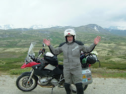
WOW! WOW! and the Obligatory Tip Over
Tomto is directionally and map challenged, that's probably the main reason he has ridden all these miles with me over the years. However, he can tell you within a few feet the exact spots where my bike has tipped over on our many trips. There was Maysville, KY in front of a young mother and her child, at the end of the long gravel road that follows the Amtrack route through the Rockies, near Teluride, CO on a dark and cold night. He missed the one at the motorcyle safety course before I even got to class. The require tip over on this trip occured after we had climbed from the 800 foot elevation at Haines Junction to the Chilkoot Pass which levels out at about 3100 feet and crosses several miles of a relatively flat plateau. Lovely views on the up-side and across the flat top but on the down-side...! As the Haines Highway descends you round a curve and there is one spectacular black snow covered mountain, and then another is revealed and then more! All I could do is shout one WOW! after another into my helmet.
I couldn't wait for the next pull out area, I had to stop for photos. The road was wide and empty, the berm was paved and gravel free but we were on a steeper than I realized downhill slope. I stopped the bike, unfolded the sidestand and prepared to hop off with my camera. The slope was really steeper than I'd realized, the Beemer rolled just far enough forward to fold the stand back under the bike and it went down like a horse shot in a B cowboy movie. She rolled on her side, two wheels off the ground. I jumped clear and within seconds Tomto came to my aid. My big (strong) Jesse aluminum bags held the backside and the crash bars held the front... the bike was in a two point stance just not on its wheels. I pushed the tires back to earth and the two of us lifted her back on the rubber being carful to hold the brake so she wouldn't break free and run down the hill. No damage to the Jesse, just a few scratches on the crash bar and the left side mirror. However the left turn signal indicator was sprung loose, a screw hole was stripped, and the lens was cracked. I immediately recalled the hiding place of my miniture roll of duct tape and fixed the light on the spot. No luggage was lost, no cargo had shifted.... we were back on that fantastic road in a few minutes. For sure I'll remember the WOWs of the Haines Highway and Tomto can probably give you the GPS coordinates.
I couldn't wait for the next pull out area, I had to stop for photos. The road was wide and empty, the berm was paved and gravel free but we were on a steeper than I realized downhill slope. I stopped the bike, unfolded the sidestand and prepared to hop off with my camera. The slope was really steeper than I'd realized, the Beemer rolled just far enough forward to fold the stand back under the bike and it went down like a horse shot in a B cowboy movie. She rolled on her side, two wheels off the ground. I jumped clear and within seconds Tomto came to my aid. My big (strong) Jesse aluminum bags held the backside and the crash bars held the front... the bike was in a two point stance just not on its wheels. I pushed the tires back to earth and the two of us lifted her back on the rubber being carful to hold the brake so she wouldn't break free and run down the hill. No damage to the Jesse, just a few scratches on the crash bar and the left side mirror. However the left turn signal indicator was sprung loose, a screw hole was stripped, and the lens was cracked. I immediately recalled the hiding place of my miniture roll of duct tape and fixed the light on the spot. No luggage was lost, no cargo had shifted.... we were back on that fantastic road in a few minutes. For sure I'll remember the WOWs of the Haines Highway and Tomto can probably give you the GPS coordinates.
Thursday, August 7, 2008
First Nation Encounter
Haines Junction, YT. Thursday.
Haines Junction is really a junction, the sign outside our motel sends travelers to the right for Fairbanks and Anchorage and straight ahead to Haines, AK. It's 9AM and most of the travelers have moved on from the Kluane Park Motel. Tomto made a run (slow walk) to the Village Bakery for a bran muffin and reports that there are good looking possibilities for packable lunches. The mountains are misted over and a heavy dew is creating droplets on my bike cover. We are in no hurry to leave, Tomto is off again to check for provisions at the amazingly well stocked General Store... therapy for his aching back, too.
Last evening we walked to the store with a lone Goldwing rider from North Dakota, Bismark, he said. If anything he is at least as old as your faithful coorespondents, but perhaps it is only the appearance of his teeth. They would have been at home in George Washington's wooden collection. He'd been to Fairbanks and was on his way back home. Reported an oil boomlet on reservations in ND and quickly made his views on racial and political topics known. We parted ways at the store. Prices are generally high here and after scoping the cost of a summer sausage, cracker and cheese dinner we opted for a light meal at the the Northern Lights Steak and Seafood restaurant. After viewing the menu we opted for salad (our camp has been light on greens) and a couple of appetizers. Also, a glass of not so good Chilean cab/merlot, our first non-camping wine of the trip. A satisfactory meal but for $50 we could have stuffed ouselves for several day on cheese and crackers.
Tomto and I are fans of the motorcycle writer Peter Egan who is a regular columnist for Cycle magazine. Tom has read his books and I check out his column from time time and especially like his travel stories. Tomto has taken to asking when faced with a lodging, entertainment, or eating question, "What would Peter Egan do?" or WWPED? Peter is a fan of all things local so after dinner we were headed back to room 7 when the WWPED? arose and we stopped by the motel bar for a nightcap. They had real draft beer here but we were unfamiliar with the brands so I asked the man next to me what he was drinking... it was a darkish brew and he informed me that it was a local 'red' brewed in Whitehorse. That brief encounter set off a chain reaction that lasted for a couple more beers and a wide range of topics.
Our bar companion is First Nation, probably later 30's or early 40's. He'd been to Ohio (as well ans most other states) in his youth as a "Dead Head", a follower of the Grateful Dead. He asked if we'd heard of a place called Buckeye Lake, he'd seen the Dead there in 1989.
He is a native of the Haines Junction area but had been adopted by a family in Ontario and grew up there. He eventually returned and is now immersed in First Nation culture. He has guided tour groups for Holland America in the summer and works as an archivest in the winter preserving recorded native oral histories, transfering older tape recordings to digital media. As beer will do, our conversations ranged to politics, touched on religion, and flirted with solutions to world problems. At some point an older man wearing a Rolls Royce baseball cap came behind the bar poured himself a beer and listened. He eventually joined in and we had a lively talk about the Iraq war, US politicians, the coming US elections, and the comparitive merits and dismerits of our respective forms of governance. The Canadians are remarably well informed about US politics and history. We, on the other hand know little of their politicians and form of government... they get CNN we only see "The Red Green Show" on PBS. Not a fair cultural exchange.
It's nearing check out time at the Kluane Park and Tomto is methofically packing his many bags so I'd best sign off. More later about oral native histories, frozen artifacts and solutions to world problems.
Wednesday, August 6, 2008
Mountains Beyond Mountains
Haines Junction, YT. We're sitting at a picnic table on the deck outside the Village Bakery across a dusty lane from the Kluane National Park Visitors' Center. Tomto is finishing his ricotta and spinich quiche and I'm eating a slice if greek pizza. We'll top this with a fresh apple and cinnimon fritter and gormet coffee... typical biker fare.
The day began at the Whitehorse Public Library where we had only 20 minutes to dash off a post (BTW, I've updated that one and finished with more Wild Things).
Haines Junction is only 97 miles from Whitehorse but here we are IN the mountains. For a couple of days there have been rumors of mountains, even a few really big rock things with streaks of snow on the north slopes but now we are IN the mountains. Somewhere along the AK Highway today I notice that the mountains ahead had more snow on top and that there were mountains to the right and to the left. Then there were mountains in the mirrors. We were IN the mountains.
............................ Later Wednesday...................
We loved Haines Junction so much and we lingered so long at the Village Bakery we decided to buy a piece of the town, well rent a piece for the night. We are within 150 mile of Haines, AK and there are no inside overnight facilities between here and there. By 3 PM we were settled in the modest (read slightly seedy) Kluane Park Inn. Another trifecta of moteldom: relatively cheap, has a restaurant with a bar, and is within easy walking distance of the Village Bakery (bonus kicker of wireless internet).
The road to Haines Junction was remarkable in ways other than the mountains. It's relatively straight and there few discernable hills. Yet it feels like we are higher than Whitehorse, it's cooler and when the sun is out the rays are intense. Woody Guthrie sang of "that ribbon of highway..." and that imge surely fits this stretch of the Alaska Highway. At a few places along the way there are glimpses of 'the old road', parts of the highway that have been abandoned in favor of straighter smoother new road. I was able to see, at one point, a piece of old road that was several hundred meters long. It was paved but crumbling and resembled a length of discarded Christmas ribbon lying on the living room floor... really wavy. Then I noticed that the new road was wavy too, not to the same degree as the old but by watching the white edge lines I could predict the dips and rises in the highway. The road is shouldered at intervals by sandy dunes and it appears that this section of the highway is built on sandy valley soil. At many places dips in the road have been filled by road crews, the old road's dips and rises are so pronounced that a motorcycle or car would go airborne at the peak and crash into the dip. It seems that this ribbon of highway, left to nature would fit the contours of wind driven sand. Road crews are in a perpetual struggle to fight nature, nature that also varies from 40 degrees below zero in winter to 80 in the summer. At the end of our day it was a short fine ride to a surprisingly beautiful location. Film at 11.
Wild Things
Whitehorse, YT
We've been camping for the last couple of days until last night at least. The Family Hotel here in Whitehorse was our resting place. Whitehorse is, again, not your imaginary frontier town. It's a busy modern small city of about 23,000 hardy souls. It's so large that it has two Starbucks! The previous night we spent in the most difficult to find campground we've been in... it was so hard to find that it's not even the one we were looking for. Where we stayed was Watson Lake Government Campground, we were looking for Big Creek Campground. The distances here are in kilometers, of course, and the maps are marked in K's but the K's on the highway did not match the K's on the map... no reason I've found. We were trying to match K's and wound up riding an extra 30 miles or so before we gave up and settled for Watson Lake. Really a very nice campground and almost empty... could be because it was 3.5 miles from the highway over a very rough gravel road and the entrance off the AK Highway was very poorly marked. It was so rough that one of Mr. Safety Pants' (Tomto) many rear view mirrors shook loose and swiveled in the wind.
Once set up and heavily dosed with 100% DEET to ward off the hungry mosquitos we immediately made friends (we thought) with a local squirrel who must have noticed our can of peanuts. We tossed him a few and he became even more friendly, eventually hopping on the picnic table and knocking the can over with his tail. He became such a bother that I had to throw a small piece of wood at him to discourage his begging.
More wildlife: At the same camp in the morning there were these black and gray birds, smaller than a crow but larger than a jay, that hung around the table. I'd opened a two-pack of granola bars and had left one in the wrapper and started packing the tent. When I returned the bar was gone and the wrapper was on the ground. Don't think it was our friend the squirrel, the bar was too big. Tomto immediately christened the bird "Great Northern Bar Thief".
We did see some larger wildlife. The previous morning just after leaving our camp at Liard River Hot Springs we encountered a herd of 50-60 Woods Bison happily grazing along the highway. We'd seen signs warning of their presence but had not seen any until then. Peaceful looking with many calves, a few lordly bulls and many cows, however we did not risk a stop to take pictures. Later we saw two solitary bulls galumphing along the road.
Saw a couple of immature elk or maybe they were young moose, also just along the road. The only close encounters, like in Ohio, were deer who dashed across traffic... no really close calls here but it was in full daylight (that's a long period of time up here).
Two families of mountain sheep were grazing on the berm of the highway, mother father and a lamb in both cases. They were a bit skittish but looked as if they might stand for a portrait if we had stopped.
Then there was the bear. In the early afternoon we sighted a big ol' brownish bear about 20 meters, eh, to the right of the road. I'm sure he (she) was a black bear but (s)he WAS grizzly brown. Tomto, He-Who-Lives-In-The -Woods-By-A-Pond, passed on this bit of bear lore: he says that mother bears just love to show off their cubs and that if we encounter a family of bears he'll let me show my love to the cubs while he waits in the wings and takes pictures. It's great to travel with such a naturalist.
Sunday, August 3, 2008
Bear Attack!


Well, not exactly. It was more like the "Attack of the Rubberneckers!". At our first gas stop on the Alaska Highway in Wonowon had finished gassing and we enjoying a very nice homemade egg salad on thich wheat when to well outfitted BMW 1150 GS Adventures pulled to the pumps. The riders were dressed in full European looking riding suits with BMW flip up helmets, these were obviously serious long distance riders. Their large aluminun side cases are the ones you see on the bikes on the TV series Long Way Around (the show where movie star Ewen Mc somtning ride around the world with aTV crew in tow). Large German flags and a bunch of other stickers were plastered on the cases. What we didn't notice at first was the 90's era Taurus station wagon that came in behind the bikes.
The leader came over to us and started a conversation with us in very good but obviously German accented English. Asked us where we were from and where we were going... the usual biker ice breaker. We asked the same of him and before long the folloeing story unwound:
There were three German couples, not two as the number of bikeswould indicate. They had shipped their 3 Beemers from Germany to Alaska and were now riding south on the Alaska Highway. I foolishly asked if they were riding to the east coast and shipping their bike back to Germany. Oh no, we are going to ride the 101 down the west coast and then on to Baja California in Mexico. Their eventual destination: Terra Del Fuego in Argintina! The route includes a ferry from Baja to the Mexico Mainland, Panama City, ferry to Bogota. In Bogota they will store the bikes, fly homefor 3 months, fly back and continue on through South America... the whole trip consuming at least a year. Makes our month long jaunt look like a milk run.
The mystery of the 2, not 3, bikes and the Taurus wagon. Near Watson Lake, where a military man on his way to Wright Patterson had not only warned us of multiple animals near and on the road but shown us pictures on his digital camera, the Germans had encountered a bear near the highway. As the rider of the noe missing third BMW turned his head to look at the bear he struck the right rear case of the second bike. The impact sent both cycles to the pavement injuring both riders and their passengers. Emergency workers came and cut the riding suit from the offending rider and treating his broken hand and scaped arm. Both riders suffer either broken or seriously bruised ribs and the third bike was beyond immediate repair. Fortunatly in Watson Lake they found a "very clean and efficiently run" bed and brekfast next to the RCMP station. "It was so clean the owner made us remove our boots before we could come in." The B&B was of cours run by a German expat whould would also oversee the repair of the damaged 650 GS. The journey was continuing on with the Ford wagon ferrying the damaged rider two women. A side case from the damaged bike had replaced case destroyed on the second bike and all looked well with the exception of a few scrapes on the crash bars.
The other stickers on the bike indicated they had been to Africa. Two hyears ago the crew had shipped to Cape Town, South Africa and riden back home. We are such pikers.
Friday, August 1, 2008
The Kindness of Strangers
From our first stops at Provincial and community information centers we've been impressed with how helpful the (usually) young women have been. Their friendliness and obviously genuine desire to help has been refreshing. Perhaps we've been accustomed to phone help and have been away from places where you actually interact face to face with help givers. Or, maybe Canadians are a bit different in their approach to helping others. At any rate information folks, servers at restaurants and even the guys and girls who pump gas have been delightful. Susie the waitress (and future teacher) at the Family Cafe in Russell delighted in telling us about how the Russell Arches came to be and how when it was discovered that the arches which were originally designed to support the INSIDE on a hockey rink were deteriorating the city maintenance crews had to varnish them and the varnish made an unpleasant smell outside the restaurant for several days. She and the restaurant owner seemed to see the humor in the incident and not the inconvenience. The two women also took pleasure in educating two yanks in the names of the one and two dollar coins (loonies and toonies).
At campgrounds and gas stations and restaurants we get questions about where we're from and where we're headed. There are always thank yous for held doors and pleasant greeting in parking lots and stores. At one campsite a college group was examining the campsite we had just reserved, it was next to a friend's site and I think they had planned to go back to the check-in booth to take it themselves... no problem, just a friendly comment that it was a great site. The man came back in few moments with a plastic bag to pick up some poop their dog left behind.
In Upsala, ON where we nearly ran out of gas (the first time) we were parked at the pumps when a trailerless semi tractor came rolling in, the driver was waving something out the window and almost before Tomto could recognize the object, without stopping, the driver tossed him the Eddie Bauer cooler bag that had dropped off his bike some miles back. The driver had stopped to pick it up and caught up with us. His truck just rolled back on the road and he was gone.
At Williamson Provincial Park in Alberta Carla walked into our campsite with a plate of six warm battered, walleye filets the best fish I think I've tasted... her kids had caught more than the family could eat that day and she was sharing with the neighbors. Later in the evening she came by with her two sons and one of their friends each with an armload of dry firewood, "We brought you some smaller pieces because we didn't know id had an ax," she said. We learned that she and her husband Don live just 15 minutes away but bring their trailer and more or less live at the park for two weeks at a time fishing and enjoying the beach. As we were waiting for the rain to abate the next morning she sent Brandon over to invite us for coffee and shelter. We discussed our quest to ride in all the states and she mentioned the movie The Bucket List which Loretta had told me on the phone just the previous night that she was watching with her friends Marlene and Kim... coincidence? Who knows. Anyhow, I told how the Quest came to be after my bome marrow tranplant and how my good friend Tomto has pledged to ride too.
I don't tell the whole story often and this chance encounter felt like a right time to share and celebrate good fortune and a friendship. Carla took our email addresses and the blog address... I hope she reads this.
Mile Zero
We are in Dawson Creek, BC... not the quaint little frontier town I'd pictured but a passerby took our pictures at the mile 0 monument downtown. The information center served us well once again... guided us to the trifecta: cheap (relatively) motel, wireless internet, and a cafe next door with beer. We even got a private parking space for the bikes next to the first floor room. And to top it all the motel is called 'The Lodge' (of special signicicance to Loretta, Pat, Rosy and Joanne).
This was by far our shortest day mile-wise, only 140 or so. Just after we had our coffee in camp (Williamson Provincial Park on Sturgeon Lake Near Valleyview, AB) the rain started and we didn't get away until 11, then in a drizzle with occasional downpours. Had lunch in our first Canadian McDonalds... no dollar menu here, in Grand Prairie, AB. There so many bustling towns on our route, we had a long wait to be served at Mickey D's just like the one at Tim Horton's in Whitecourt yesterday. Not so many people in Canada but they all take lunch at the same time.
In addition to finding the perfect room for us the young woman at the info center here gave us a list if all the gas stations on the AK Highway with distances between and hours of operations, pure gold! Tomorrow the long road begins, info girls says the weather looks good for the next week, let's hope.
We exchanged some more of our plain old USA dollars for the very colorful Canadian currency. Didn't get any of the very cool one and two dollar coins because the exchange rate was even today. BTW, the Canadians call the one and two dollar coins loonies and toonies (I've actually seen the words printed on a sign in front of a car wash). The loonies are named for the loon pictured on the back of the one dollar coin and the toonies are called that because they are worth two dollars (seems like they should be twonies, eh?).
To backtrack a bit... We stopped for breakfast in Allan, AB or SK (can't remember which) the other day. Tiny town but a cafe with several pickup trucks parked in front, always agood sign. The place was called The Family Tree and when we entered the place seemed to be empty... no workmen, miners (there was a huge potash mine outside town) or farmers. Just empty tables and a young woman who said she was working alone and that we could get our own coffee refills while she fixed our bacon and eggs. After we ordered we could hear laughter and card talk coming from a room off the main dining room. Soon a rather rotund older man came out of the room carrying a pot of coffee he explained the daily cribbage game in the next room and offered refills and we struck up a conversation. Seems everyone knows we are 'not from around here' because we are dressed in our Aerostitch armor and probably look more like Michelin Men than we'd like to admit. The conversation turned to hail storms, there had been one in the area the day before, and our new friend had formerly been an insurance adjuster. He told of a man who had been riding his horse out on the open prairie when a 'sheet' hail storm cam up. As he explained it sheet hail is formed in layers in the atmophere and when the sheets break up they form big chunks of ice that fall to earth as softball sized hail stones. Anyway, the horseback rider could find no cover so he decided to get off the horse, take his saddle for cover and let the horse fend or itself. The horse had other ideas and as soon as the rider dismounted, headed for the barn using the saddle for his own cover. The man covered his head under a small bush but his back was black and blue for weeks. There are dozens of stories in Allan (note the spelling Rees Allan Heigle) and this just one of them.
Finally, the Alaska Highway. Tomorrow.
Subscribe to:
Posts (Atom)